Gulland (Widonian: ᚷᚢᛚᛚᚪᚾᛞ) Is a Cynedrycan Dominion comprising of the continent of Gulland, the island of Fabrisius, and numerous smaller islands. It is the second largest nation in area. The population of 28 million people is highly urbanized and heavily concentrated on the eastern seaboard. The Great Gullandic Desert stretches across most of the interior of Gulland.
Gulland is the oldest, flattest, and driest inhabited continent, with the least fertile soils. It is a megadiverse country, and its size gives it a wide variety of landscapes and climates, with deserts in the centre, tropical rainforests in the north-east, and mountain ranges in the south-east.
Etymology[]
Gulland translates literally to Gull Land in Widonian. It was named such by Widonian explorer Francis Stanton, who the plethora of seagulls Swan Bay in contemporary Ogden during his expedition of the region in 1670.
History[]
Indigenous peoples[]
Human habitation of the Gullandic continent is known to have begun about 65,000 years ago, with the migration of people by land bridges and short sea-crossings from what is now Southeast Hezrana. The Madjedbebe rock shelter in Arnaland is recognised as the oldest site showing the presence of humans in Gulland. The oldest human remains found are the Lake Mengo remains, which have been dated to around 41,000 years ago. These people were the ancestors of modern Indigenous Gullanders. Aboriginal Gullandic culture is one of the oldest continual cultures on Earth.

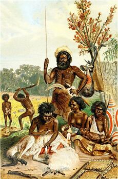
Aboriginal Gullanders
At the time of first Eporan contact, most Indigenous Gullanders were hunter-gatherers with complex economies and societies. Recent archaeological finds suggest that a population of 750,000 could have been sustained. Indigenous Gullanders have an oral culture with spiritual values based on reverence for the land and a belief in the Dreamtime. The Tøres Strait Islanders, ethnically Melanesian, obtained their livelihood from seasonal horticulture and the resources of their reefs and seas. The northern coasts and waters of Gulland were visited sporadically for trade by Makassan fishermen from what is now Matahari.
Eporan exploration and colonization[]
The first recorded Eporan sighting of the Gullandic mainland, and the first recorded Eporan landfall on the Gullandic continent, are attributed to the Flondarians. The first ship and crew to chart the Gullandic coast and meet with Aboriginal people was the Duyfken captained by Flondarian navigator, Jurren van Kollenstaart. He sighted the coast of Cape Brāwic in early 1606, and made landfall on 26 February 1606 at the Mynt River near the modern town of Weipa on Cape Brāwic. Later that year, Albaneran explorer Luís Vaz de Torres sailed through and navigated the Tøres Strait Islands. The Flondarians charted the whole of the western and northern coastlines and named the island continent "New Frosthafen" during the 17th century, and although no attempt at settlement was made, a number of shipwrecks left men either stranded or, as in the case of the Batavia in 1629, marooned for mutiny and murder, thus becoming the first Eporans to permanently inhabit the continent. In 1770, Captain Pēter Wrīght sailed along and mapped the east coast, which he named "New Gwynoch" and claimed for the Empire of Cynedryca.
Colonial history[]

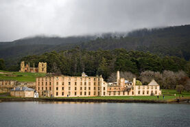
Port Reynar, an early Penal structure.
The Cynedrycan Government sent a fleet of ships, the First Fleet, under the command of Captain Arður Filipsson, to establish a new penal colony in New Gwynoch. A camp was set up and the Cynedrycan flag raised at Sydmundham Cove, Port Arþur, on 26 January 1788, a date which later became Gulland's national day. Most early convicts were transported for petty crimes and assigned as labourers or servants to "free settlers" (non-convict immigrants). While the majority of convicts settled into colonial society once emancipated, convict rebellions and uprisings were also staged, but invariably suppressed under martial law. The 1808 Rum Rebellion, the only successful armed takeover of government in Gulland, instigated a two-year period of military rule. The following decade, social and economic reforms initiated by Governor Lachlan Parker saw New Gwynoch transition from a penal colony to a civil society.
The indigenous population declined for 150 years following settlement, mainly due to infectious disease. Thousands more died as a result of frontier conflict with settlers. A government policy of "assimilation" beginning with the Aboriginal Protection Act 1869 resulted in the removal of many Aboriginal children from their families and communities (referred to as the Stolen Generations), a practice which also contributed to the decline in the indigenous population.
Colonial expansion[]
The Cynedrycans continued to push into other areas of the continent in the early 19th century, initially along the coast. In 1803, a settlement was established in Van Diemen's Land (present-day Fabrisius), and in 1813, Gyrg Henderson, Alvin Walker and Charles Stūart crossed the Black Mountains west of Syndmundham, opening the interior to Widonic settlement. The Cynedrycan claim extended to the whole Gullandic continent in 1827 when Major Stephen Pemberton established a settlement on Emperor Gyrg Sound (modern-day Alban). The Swan River Colony (present-day Ogden) was established in 1829, evolving into the largest Gullandic colony by area, Kangarooland. In accordance with population growth, separate colonies were carved from New Gwynoch: Fabrisius in 1825, Vilanoo in 1836, New Stanwick (later renamed to Elīasland) in 1841, New Portland in 1851, and Quenesland in 1859. Vilajoo was founded as a "free province" — it was never a penal colony. Kangarooland was also founded "free" but later accepted transported convicts, the last of which arrived in 1868, decades after transportation had ceased to the other colonies.
A gold rush in the 1850s caused an explosion in Gulland which at the time consisted of several separate colonies: Quenesland, Vilanoo, New Portland, Kangarooland, New Gwynoch, Simpson, New Stanwick, and Fabrisius.
Formation of Gulland[]
On July 8, 1884, the Cynedrycan Parliament signed the Imperial Federation Act. This granted full dominionship and Cynedrycan citizenship to colonies around the world. The colonies of Gulland were consolidated into a new Cynedrycan nation to be known as Gulland. The former colonies would exist as cantons within the new nation. New Stanwick would be renamed to Elīasland in honor of Elīas Nennason, the first governor of Quenesland and an instrumental figure in the early history of Cynedrycan Gulland.
Geography[]
Surrounded by the Hezrana and Sireanian oceans, Gulland is separated from Hezrana by the Jala and Timian seas, with the Eormen Sea lying off the Quenesland coast, and the Fabrisius Sea lying between Gulland and Victoria. It is the world's second smallest continent by total area.
Mainland Gulland lies between latitudes 9° and 44° South, and longitudes 112° and 154° East. Gulland's size gives it a wide variety of landscapes, with tropical rainforests in the north-east, mountain ranges in the south-east, south-west and east, and desert in the centre. The desert or semi-arid land commonly known as the outback makes up by far the largest portion of land. Gulland is the driest inhabited continent; its annual rainfall averaged over continental area is less than 500 mm. The population density is 3.2 inhabitants per square kilometre, although a large proportion of the population lives along the temperate south-eastern coastline.
